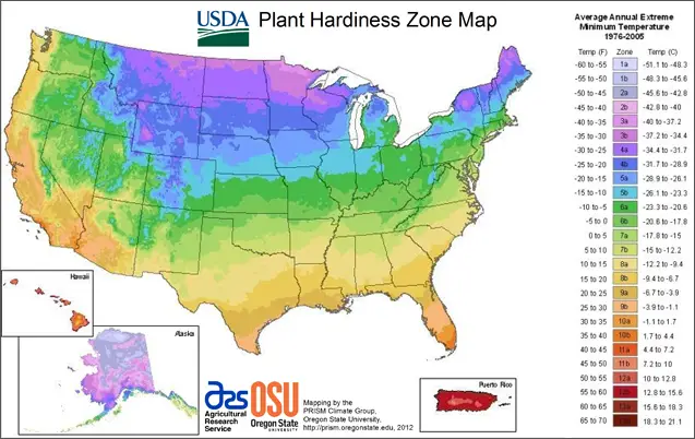
USDA Plant Hardiness Zones Map
The USDA Plant Hardiness Zones Map is a valuable agricultural and horticultural reference. Users often ask about the USDA Plant Hardiness Zones Map to know if they can cultivate specific plant species in a specific area or not. The USDA Plant Hardiness Zone Map is a product of the USDA Agricultural Research Service (ARS), with assistance from the PRISM Climate Group at the Oregon State University.
What is Plant hardiness zones map about?
The USDA Plant Hardiness Zone Map tells the temperature range in a specific area. I.e. It'll tell the lowest and the highest temperatures of a zone. So, you'll be able to take care of your plants according to the environment and their needs.
The Interactive USDA Plant Hardiness Zones Map
The USDA Plant Hardiness Zone Map is interactive, where you can search by your area zip code or filtering by state.
Please have a look at https://planthardiness.ars.usda.gov/PHZMWeb/.

Why USDA hardiness zones map is useful?
Some plant species can survive in an intensive cold temperature while others will die. So if you need to grow a plant in your area, it is best to learn about the max cold the plant can withstand and then check your area temperature range in this hardiness zones map.
This way, you'll understand whether you can plant that particular plant type in your area or not. If it is colder than what your desired plant can survive in, you can then manage to plant in a container. So you'll be able to bring it inside in a colder season.
The USDA Hardiness Zones Map is particularly beneficial for Succulents growers. You can plan before growing your types of succulents. You'll also need this map to water your succulents.
We've written an in-depth guide for making DIY perfect soil for your succulents OR get the best succulents soil from the market.
